![]()
Warblington School
The Travel Planning Team at Hampshire County Council has been working with Warblington School to produce two bespoke maps to support students with travelling actively to school*
*This project has been funded by Developer Contributions as part of the Harbour Place development (Harbour Place, Havant Road, Bedhampton, Havant, Hampshire, PO9 3LW).
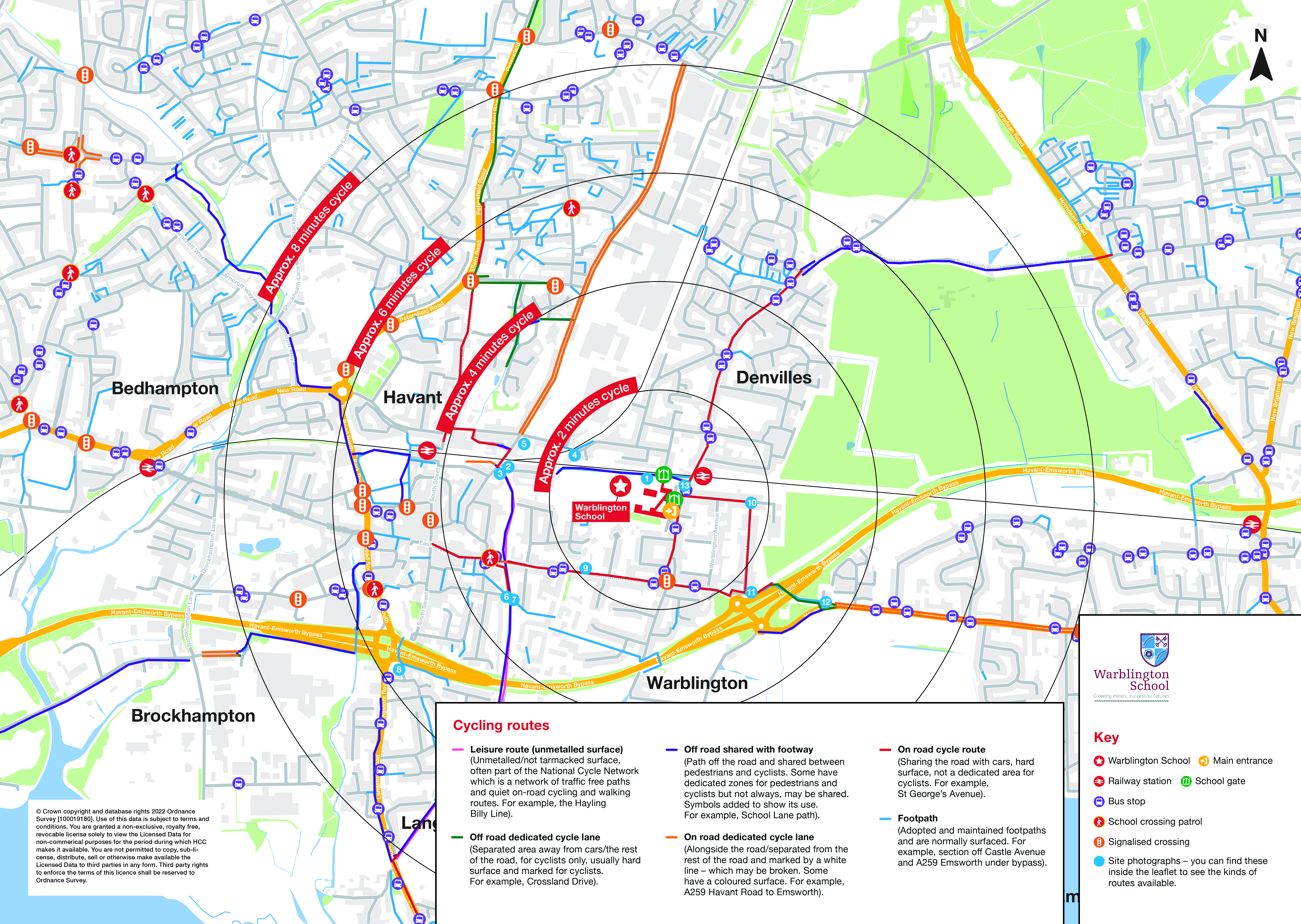
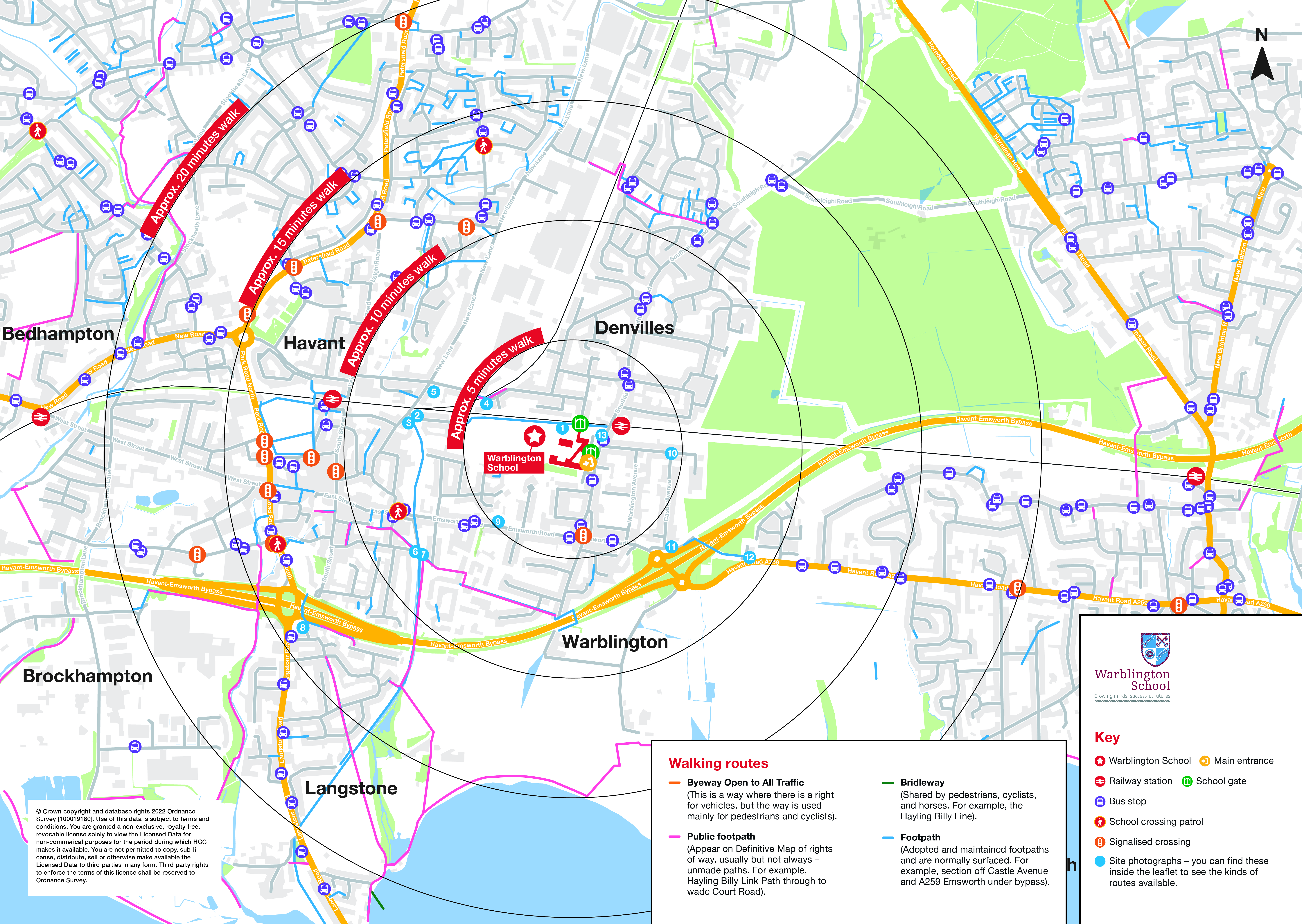
Warblington School cycling map Warblington School walking map
Please check out the routes and have a practice, it is your responsibility to make sure they are safe.
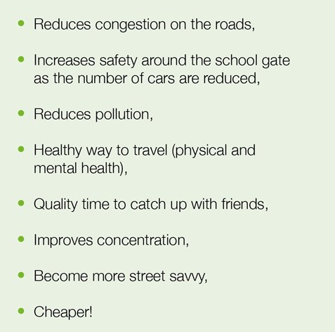
The benefits of walking or cycling to and from school - for all or part of the journey.
Warblington School Cycling and Walking leaflets:

Digital version - Cycle to Warblington School
Print version - Cycle to Warblington School

Digital version - Walking to Warblington School
Print version - Walking to Warblinton School
If travelling from Harbour Place to Warblington School
Buses
Frequent Stagecoach bus service 23 supports pupils at Warblington School. This service stops at the bus stop Forty Acres on the Havant Road just outside of Harbour Place. The bus stops at Havant Bus Station which is a 0.9 mile / 17 minute onward walk to Warblington School.
You could alternatively change to the Stagecoach service 700 at Havant Bus Station which is an onward 3-minute bus journey to Warblington School stopping at Green Pond Corner stop (approx. every 20 minutes).
Both outward and return journeys fit well with the school day.
For detailed information on times/stops, see: https://www.stagecoachbus.com/


Walking route to Warblington School

Harbour Place to Warblington School walking route map
Approximately 1.65 Miles / 2661 meters / 3950 steps to Warblington School. Around 40 minutes walking.


Join the footpath at Forty Acres Way.
This wide hard surfaced path leads you towards the A3(M) junction/Rusty Cutter roundabout. Here you will find a succession of signalised crossing points connected by short sections of path, please see the images below.

When you reach the final section at the base of Bedhampton Hill, you have a number of route options. You could:
- Continue to walk on the north side of Bedhampton Hill. Cross at the junction with Portsdown Hill Road and continue on Bedhampton Road. Cross Hulbert Road using the signalised crossing point. Continue on New Road until you reach the roundabout then cross the Petersfield Road using the signalised crossing point and head straight across onto Elmleigh Road. Use the crossing to proceed onto Eastern Road. On Eastern Road you will see a footbridge which will take you across the railway line. This finishes in Third Avenue. Follow this road, turn left into Second Avenue, right into First Avenue and then right onto Southleigh Road. Follow this crossing the railway and reach Warblington School.
- As above up to Elmleigh Road but when you meet the junction with New Lane, turn right. Turn left onto School Lane and follow the signed route through the housing estate and onto the footpath/cycle track that lead up to Warblington School.
- Alternatively, to pick up the route across Lower Bedhampton: you have two options:
 a) Cross the final section at the base of Bedhampton Hill leading on to Lower Road with extra care as there is not a signalised crossing point here (as shown in the images on the right). From here you can follow Lower Road onto Brookside Road and then right onto Bedhampton Road. Once at Bidbury Mead walk north on the footpath and exit Bidbury Mead where it joins Bedhampton Road. Cross the signalised crossing at end of lane onto north side of Bedhampton Road and continue on to New Road. Then follow instructions at 1 above from “continue on New Road….”.
b) As above but alternatively at Bidbury Mead, you can also travel across the Bidbury and Bedhampton Park from the Bidbury Mead P&S (good path). Follow the pavement on King’s Croft Lane towards the junction with Bedhampton Road (north). Walk a short distance on the south side of Bedhampton Road to the signalised crossing opposite Brake House. Then follow instructions at 1 above from “continue on New Road….”.
 Car Journey / 5-10 Minute Walking Bubble:
If you do consider yourself an essential driver, please do try and avoid coming all the way to Southleigh Road and instead drop your child safely and considerately on a suitable side street to walk in to school, which will take between 5-10 minutes.
Please always park safely, legally and considerately.
Please check out the routes and have a practise, it is your responsibility to make sure they are safe.
If you are travelling from Harbour Place, Paul Basham Associates will provide you with a School Travel Pack which will contain a guide on how to travel to school sustainably and efficiently.
Keep an eye on our events at: Secondary Events and Challenges | My Journey Hampshire
Why not look at our road safety pages: Road safety for secondary | My Journey Hampshire
For ideas and resources to help your family get active, visit our Secondary Wellbeing pages: Secondary wellbeing | My Journey Hampshire
Information on Route Guard app:
Senior school children often travel more independently and our secondary road safety page contains helpful information for schools, parents and pupils, including details about the Route Guard app. This app is a great way of allowing parents and carers to actively engage with their young people, planning routes and agreeing boundaries for safe and independent travel.
Social media:
We put lots of information on our social media channels about active travel. Do like and follow us:
![]()
![]()
![]()